
Live in Five Points
Two City neighborhoods either side of Piedras Street, where the Montana Brio starts and most homes are rented, priced well below the county median, and where FEMA's preliminary map draws a flood zone along Cebada Street that the effective map does not show online.
Five Points took its name from the junction of Piedras Street, Pershing Drive and Elm Street, and Piedras Street became the city's eastern limit in 1891; its commercial core at Montana Avenue and Piedras Street keeps buildings like the Stevens Building at 801 North Piedras, from 1921. This guide takes the City's Five Points East and Five Points West neighborhoods together as its boundary, 368 acres between Interstate 10, Grant Avenue and Montana Avenue, where the 2020 census counted 2,645 residents, down from 3,291 on about the same ground in 2010, and 57% of the occupied homes were rented. Zillow's typical value for ZIP code 79903, which holds 93% of the residents, was $181,991 in August 2026, up 2.2% on the year, but the ZIP holds six times as many people and is not a Five Points price. No City historic district reaches it, so a house here carries no certificate of appropriateness.
A crossroads on the old city line that became a bus terminal, and lost a fifth of its people in ten years
Two features of the City of El Paso's Neighborhood Boundaries layer taken together, Five Points East (FID 105, 196 acres) and Five Points West (FID 115, 172 acres), about 368 acres, traced against the Census Bureau's road file. Five Points West runs from Grant Avenue on the north and Cotton Street on the west down to Interstate 10, with Piedras Street on the east. Five Points East runs from Piedras Street east to Gateway Boulevard South beside US 54, with Montana Avenue on the north and, on the south, the Interstate 10 frontage at Cebada Street, stepping north up Stevens Street to Yandell Drive at its eastern end. The Five Points Development Association's registered area is larger, 7,136 residents in 2020, and holds 2,436 of this guide's. All of it is in El Paso County and El Paso ISD, and the reference point is in City Council District 2, with 751 of the residents in District 8.
Five Points took its name from a junction: Piedras Street, Pershing Drive and Elm Street, which no longer runs through. In 1891 the city extended its eastern limit to Piedras Street, and the corner of Montana Avenue and Piedras keeps commercial buildings from the years after, the Stevens Building at 801 North Piedras among them, from 1921. This guide takes the City's Five Points East and Five Points West neighborhoods together as its boundary: 368 acres from Grant Avenue and Montana Avenue down to Interstate 10, split by Piedras Street, where the 2020 census counted 2,645 residents, roughly 2,600 people, against 3,291 on about the same ground in 2010. That is a fifth fewer in a decade; the census does not say why.
Most homes here are rented, and much of the ground is commercial. Of the 1,049 occupied homes in 2020, 598 were rented and owners lived in 451, 43%, and 199 more stood empty. The Five Points Development Association, incorporated in January 1986, says the City Council rezoned most of Five Points to heavy commercial in the 1950s, a decision it calls shortsighted. This guide did not read the current zoning map, so ask the City what a lot and its neighbors are zoned. No City historic district reaches the line, so exterior work needs no certificate of appropriateness.
The price is low, and the tax rate is the highest of the Texas cities here. Zillow's typical value for ZIP code 79903, where the reference point and 93% of the residents are, was $181,991 in August 2026, up 2.2% on the year, but the ZIP holds six times as many people as Five Points and is not a price for these blocks. The five taxing units on a City and El Paso ISD address add to 2.643693 per $100 for 2025. The school district takes the state's $140,000 off a homestead, the City and the County only $5,000 each, and El Paso Community College and University Medical Center nothing, so a homestead at the 79903 figure owes about $3,237 a year, the same house without the exemption about $4,811, and a homestead at the $280,615 county median about $5,845. The arithmetic is on the El Paso page.
The flood map that counts is not online here, and the one coming draws a zone. FEMA's effective map has no digital panel over Five Points, so a lot's zone has to be read on the scanned panel at FEMA's Map Service Center. The preliminary countywide map, issued on 8 August 2025 and not yet in force, puts 7.3% of the guide in the 1% annual chance zone, with 102 residents, and 3.6% in the 0.2% zone. The water it models is street and channel flow: a reach it calls Cebada Street flooding by Interstate 10, the Government Hills Channel, and ponds at Gateway East and West. A preliminary map can change before it takes effect.
The buses start here; nothing runs every fifteen minutes. Sun Metro's Five Points terminal on Montana Avenue is the western end of the Montana Brio, every 30 to 35 minutes, and a stop on the Dyer Brio, every 20 to 25. University Medical Center is about 3.5 km by road and the Bridge of the Americas about 2.5 km south.
- Ask the City's planning office what the lot and the lots beside it are zoned
- Read the 2006 FIRM panel for the address at FEMA's Map Service Center, then the preliminary map
- Run the address through El Paso ISD's zone maps: the guide splits between Moreno and Coldwell
- File for the homestead exemption with the El Paso Central Appraisal District once you live there
How Five Points got here
- 1891The city's eastern limit is extended to Piedras Street, when El Paso had about 30,000 people, in the Five Points Development Association's account.
- 1901Ten years later, the association records, the rail line between El Paso and Tucumcari, New Mexico, is laid to carry the products of the region's mines.
- 1921The Stevens Building goes up at 801 North Piedras Street, one of the commercial buildings that still mark the Montana and Piedras corner.
- 1950sThe City Council rezones most of Five Points to C-4, heavy commercial, a decision the association calls shortsighted.
- 1986The Five Points Development Association is incorporated in January.
- 2006FEMA's effective flood panels for the City of El Paso take effect on 16 February; none of the digital ones covers Five Points. That summer's storms bring a year's rain in two days and push the City and El Paso Water to a stormwater master plan.
- 2010The census counts 3,291 residents on the blocks inside today's two neighborhoods.
- 2020The census counts 2,645 residents and 1,248 homes inside the line; owners live in 451 of the 1,049 occupied homes.
- 2025FEMA issues its preliminary countywide flood map on 8 August; it puts 7.3% of the guide in the 1% zone, along the Cebada Street flooding reach and the Government Hills Channel.
- 2026El Paso ISD declares financial exigency on 4 June after finding a $52.8 million shortfall; on Thanksgiving Day, 26 November, the 90th Sun Bowl Parade runs down Montana Avenue to Copia Street.


A small park inside the line, and the big one just across Montana
Inside the line, Mary Webb Park is 1.9 acres on Missouri Avenue beside the Leona Ford Washington Recreation Center. North across Montana Avenue, Memorial Park is 44 acres on Copia Street, with the City's Memorial Aquatic Center, the Memorial Park library branch and a rose garden at Copia and Aurora.

What the map does not show: the heat and the dust. The 1991 to 2020 normal at El Paso International brings about 117 days a year reaching 32 °C, and the windy season peaks in March and April; in 2025 the National Weather Service counted 12 dust storms.
Elsewhere in El Paso, not Five Points


24 places, with real drive times
Road-adjusted distance and drive time from the centre of the community to each destination, nearest first. Filter by category.
Showing 1–12 of 24 places, nearest first.
Method: distances are straight lines from the population-weighted center of the two neighborhoods' census blocks, multiplied by a road factor, with a tiered speed model for the drive: honest ranges, not routed times.
Every gym within reach
The City's Leona Ford Washington Recreation Center is inside Five Points East, and the City lists it as temporarily closed. The nearest open one is the Chamizal Community Center south of Interstate 10, and the nearest pool is the indoor Memorial Aquatic Center in Memorial Park, open all year.
- Memorial Aquatic Center: about 1.5 km, closed Sunday
- Chamizal Community Center: about 2.1 km, gym and weight room
- Loya Family YMCA: about 18 km, the nearest Y
| Facility | What it is | Drive |
|---|---|---|
| Memorial Aquatic Center open | The City's indoor pool at 3251 Copper Avenue in Memorial Park, a 25-yard competitive pool open year-round: 5 a.m. to noon and 5:30 to 9 p.m. Monday to Thursday, closed 7 to 8:30 a.m. for school practice, mornings only on Friday and Saturday, closed Sunday. $3 for adults, $2 for children and seniors. | 4–5 min |
| Chamizal Community Center open | The nearest open City recreation center, at 2119 Cypress Avenue south of Interstate 10: a large gym, a weight room, pickleball and outside courts, and a library branch. Open 9 a.m. to 8 p.m. Monday to Thursday and 9 a.m. to 2 p.m. on Friday and Saturday. | 5–7 min |
| Fred and Maria Loya Family YMCA open | The nearest YMCA of El Paso branch, at 2044 Trawood Drive on the east side; the association has two. Open 5 a.m. to 8 p.m. Monday to Thursday, to 7 p.m. on Friday, 8 a.m. to 4 p.m. on Saturday, and closed Sunday. | 13–20 min |
| Leona Ford Washington Recreation Center closed | The City's recreation center at 3400 East Missouri Avenue, inside Five Points East beside Mary Webb Park, the nearest to the reference point. The City's recreation centers page lists it as temporarily closed and gives no reopening date. | 2–4 min |
The free option is Memorial Park's 44 acres, a walk north across Montana Avenue.
One middle school and one high school for every block, and two elementaries split down the middle
Every block is in the El Paso Independent School District. Its 2026-27 zone files send the whole guide to Captain Gabriel Navarrete Middle School, rated C (77) for 2026, and Austin High School, B (80). The elementary zone splits: the reference point is in Moreno Elementary's zone, C (72) after B (89) a year earlier, but more residents, 1,390 against 1,255, are in Coldwell Elementary's, A (91).
| School | Board | Note |
|---|---|---|
| Moreno Elementary School | El Paso Independent School District | 2300 San Diego Avenue, prekindergarten to grade 5. El Paso ISD's 2026-27 zone files put the reference point and 1,255 of the guide's 2020 residents in its zone. The Texas Education Agency rated it C, 72, for 2026 after B, 89, for 2025. |
| Coldwell Elementary School | El Paso Independent School District | 4101 Altura Avenue, north of Memorial Park. The same zone files put 1,390 of the guide's residents, the larger share, in its zone, so which of the two elementaries a house gets depends on the block. Rated A, 91, for 2026 after B, 81, for 2025. |
| Captain Gabriel Navarrete Middle School | El Paso Independent School District | 3501 Hayes Avenue, grades 6 to 8, zoned to every block in the guide for 2026-27. Rated C, 77, for 2026 and C, 78, for 2025. |
| Austin High School | El Paso Independent School District | 3500 Memphis Avenue, grades 9 to 12, zoned to every block in the guide for 2026-27. Rated B, 80, for 2026 after C, 75, for 2025. The district declared financial exigency in June 2026; ask it whether any campus in this feeder pattern is under review before relying on it. |
Run your own address. The district's address lookup was down when this guide was researched, so the zones here are its published 2026-27 maps. It declared financial exigency in June 2026 over a $52.8 million shortfall; ask whether any campus in this feeder pattern is under review before you rely on it.
Month by month, what living here looks like
Not a highlights reel: the actual annual rhythm, including the dates residents have to remember.
- The El Paso Central Appraisal District values every property as of 1 January; last year's bill is due by 31 January
- Highs near 15 °C and lows near 1 °C at El Paso International, with about 14 nights at or below freezing on the 1991 to 2020 normal
- About 10 mm of rain and 20 mm of snow on the normal
- Penalty and interest start on unpaid tax bills on 1 February
- Highs near 18 °C and lows near 4 °C; dust events can start this early, the National Weather Service says
- The windy season climbs to its peak in March and April; 2025 brought 12 dust storms, by the National Weather Service's count
- The Market opens its 2026 season of Saturdays around San Jacinto Plaza on 7 March
- Highs near 22 °C and 6 mm of rain
- Highs near 27 °C and 4 mm of rain, the driest month on the normal
- Still the peak of the dust season
- 15 May, or 30 days after the appraisal notice is mailed if that is later, is the deadline to protest a value
- Highs near 32 °C, with about 16 days reaching 32 °C (90 °F)
- Highs near 36 °C, the hottest afternoons of the year, with about 11 days reaching 38 °C (100 °F)
- 18 mm of rain as the monsoon gathers
- The monsoon arrives: 40 mm of rain on the normal, falling in short, heavy storms; in 2006 a year's rain fell in two days
- Highs near 35 °C and the warmest nights, near 23 °C
- 42 mm of rain, the wettest month; FEMA's preliminary map puts 102 of the guide's residents in its 1% zone along the Cebada Street reach and the Government Hills Channel
- Highs near 34 °C
- 39 mm of rain as the monsoon ends, and highs near 31 °C
- The Market's last 2026 Saturdays downtown, 5 and 19 September
- Chalk the Block fills the Downtown Arts District on 3 and 4 October 2026; the City's Día de los Muertos festival is downtown on 24 October
- Highs near 26 °C and 15 mm of rain
- The 90th Sun Bowl Parade runs down Montana Avenue from Ochoa Street to Copia Street at 10 a.m. on Thanksgiving Day, 26 November 2026, along Five Points' northern edge
- Highs near 19 °C, lows near 6 °C and about five freezing nights
- Highs near 14 °C and lows near 1 °C, with about 14 freezing nights and 33 mm of snow on the normal
- The 93rd Sun Bowl game is at UTEP's Sun Bowl Stadium at noon on 31 December 2026; the tax bill for the year is due by 31 January
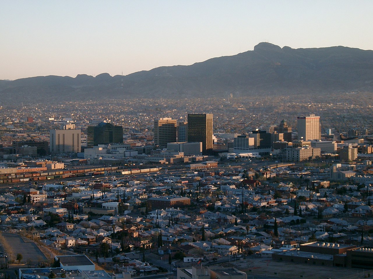
Every photograph in this guide's library is above
This library holds one photograph and the page has already printed it. The credits are in the footer.
About these photographs. Openly licensed images geotagged in or near Five Points, found on Wikimedia Commons and served from there with full attribution. Inline photos elsewhere on the page may still come from the site's shared El Paso library.