Live in Swiss Avenue
Dallas's first historic district, about 200 houses built from 1905 on along Swiss Avenue and the streets behind it, where any new building or exterior change needs the City's certificate of appropriateness and a house on the avenue keeps a front yard of at least 65 feet.
Robert S. Munger's Munger Place addition put its first house on Swiss Avenue in 1905, and most of the roughly 200 houses the City counts went up in the 1910s and 1920s, to designs by architects including Hal Thomson, Lang & Witchell and Bertram Hill. In 1973 the avenue became the City's first historic district, 116.88 acres from Fitzhugh Avenue to La Vista Drive that also take in Bryan Parkway, and its ordinance, PD 63, requires a certificate of appropriateness for any new building, exterior alteration or structure in a yard. The appraisal roll counts 192 single-family houses; the 2020 census counted 1,705 people on the 30 blocks around them, a figure that takes in apartments on Gaston Avenue and Live Oak Street outside the line. Zillow put the typical home in ZIP code 75214, which holds two-thirds of the houses, at $841,168 in August 2026.
The city's first historic district, where a 65-foot front yard and the paint color are both reviewed
The City of Dallas's Swiss Avenue Historic District, H/1, which is Planned Development District 63: in the ordinance's words, property generally southeast of Live Oak Street, south of La Vista Drive, northwest of the alley between Swiss Avenue and Gaston Avenue and northeast of Fitzhugh Avenue, about 116.88 acres. It takes in Swiss Avenue from Fitzhugh Avenue to La Vista Drive and parts of Bryan Parkway, Bryan Street, La Vista Drive, Live Oak Street and Beacon Street. The National Register district listed in 1974, Swiss Avenue between Fitzhugh and La Vista, is smaller: Wikipedia gives it 57.1 acres. On the City's map of historic districts, Peak's Suburban Addition adjoins it at the Fitzhugh Avenue end, Munger Place lies about 150 meters to the southeast beyond Gaston Avenue, and Junius Heights about 90 meters to the southeast, farther east.
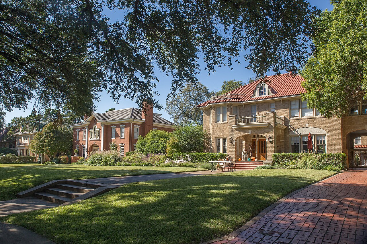
Swiss Avenue, in its association's telling, was the centerpiece of Munger Place, the addition the cotton gin maker Robert S. Munger began after turning to real estate in 1902, billed as the first deed-restricted community in Texas. Dr. R.W. Baird built the first house, at 5303 Swiss, in 1905. The association's history says the deeds demanded two stories, brick or masonry and at least $10,000 of house, and most of the roughly 200 houses the City counts went up in the 1910s and 1920s, to designs by Hal Thomson, Lang & Witchell, Bertram Hill and others. This guide covers the Swiss Avenue Historic District as the City draws it: 116.88 acres from Fitzhugh Avenue to La Vista Drive, between Live Oak Street and the alley behind Gaston Avenue, taking in Bryan Parkway.
Nothing on the outside changes without a certificate. PD 63, the district's ordinance since 1973, makes it an offense to build, alter an exterior or put a structure in a yard without a certificate of appropriateness. Staff decide routine repairs and minor work, such as paint inside the approved color range or solar panels on the rear half of the roof, within 10 days; anything more goes to a public hearing before the Landmark Commission. On the Swiss Avenue lots of Area A, a house keeps a front yard of at least 65 feet, covers no more than a quarter of its lot and stands no taller than 36 feet, with no front-yard fence or circular drive. Repainting in a new color is not routine maintenance, and no building in the district may add a dwelling unit.
The census count describes the blocks, not the houses. The appraisal roll has 192 single-family houses in the district: 101 face the avenue on a median lot of 21,073 square feet, about half an acre, and 63 face Bryan Parkway on 7,440. The 2020 census counted 1,705 people on the 30 blocks whose internal point falls inside the line, but 12 of the 20 populated blocks run back to apartments on Gaston Avenue or Live Oak Street and hold 1,409 of them. Across all 30 blocks, owners lived in 261 of 788 occupied homes; on the eight populated blocks wholly inside, in 80 of 95.
No price index follows the district. Zillow's figure for ZIP code 75214, which holds 127 of the 192 houses and 35,664 people, was $841,168 in August 2026, up 4.1% on the year, and 75206, which holds the rest, was $608,484; the citywide MLS median single-family sale was $469,900, down 6.0%. None of the three is a price for a house on the avenue. On the 2025 rates a homestead at the 75214 figure owes the five taxing units about $14,429 a year, and about $18,730 without the exemption; the arithmetic is on the Dallas page. The City still describes a historic tax exemption for rehabilitation, but the copy of the code it links to stops new certificates after 31 December 2020.
The flood map here is the City's own. Its floodplain layer shows no A or AE zone in the district, but it marks 70% of the area as a "1 PCT stormwater hazard area" and half as "Peak's Branch PFP", names its metadata does not define; 114 of the 192 houses sit in the first at the middle of the lot. The Mill Creek drainage tunnel voters approved in 2012 serves Peaks Branch, but the City's FAQ says it will not appreciably reduce flooding upstream of it, and this guide could not find which side the district is on. Day to day, DART's Route 9 runs along Gaston Avenue every 15 minutes at peak on weekdays, rail is about 2 km off, and Jimmy's Food Store and Sprouts are the nearest groceries.

- Read the rules for the lot's own area before offering on a house you mean to change or add to
- Allow for a Landmark Commission hearing on anything beyond routine repairs, paint in the approved range and minor work
- Ask the Office of Historic Preservation whether the rehabilitation tax exemption is open, since the code it links to stopped new certificates after 2020
- Pull the City's floodplain map for the lot: 114 of the 192 houses sit in its stormwater hazard area
- Work the tax out on your own price, because the seller's capped value ends with the sale
How Swiss Avenue got here
- 1857Swiss Avenue is named, by Wikipedia's account, by a Dallas resident from Switzerland, long before serious building on it.
- 1902Robert S. Munger, a cotton gin manufacturer, turns to real estate with his son Collett. Their Munger Place, which the avenue was part of, is billed as the first deed-restricted community in Texas.
- 1905Dr. R.W. Baird builds the first house on the avenue, a Classical Revival house at 5303 Swiss. The association's history says Munger Place required houses of at least two stories, of brick or masonry, costing at least $10,000.
- 1914Garrett Park, 5.2 acres on North Garrett Avenue northwest of today's district, is established.
- 1917The house at 5500 Swiss, designed by Hal Thomson and Marion Fooshee, is finished after two years' work; the banker George N. Aldredge buys it in 1921.
- 1929The Episcopal cathedral of Saint Matthew moves in July to Ross Avenue at Henderson Avenue, northwest of today's district beyond Live Oak Street.
- 1973On 10 September the City Council passes Ordinance 14247, establishing PD 63, the Swiss Avenue Historic District, the city's first; Wikipedia dates the designation to 9 July. The association credits Virginia Savage McAlester and her parents, Dorothy and Wallace Savage, with leading the preservation effort.
- 1974The district is listed on the National Register of Historic Places on 28 March, and the Aldredge family gives the house at 5500 Swiss to the Dallas County Medical Society Alliance Foundation.
- 1981Munger Place, southeast beyond Gaston Avenue, becomes a City historic district on 20 August.
- 1982On 3 February Ordinance 17285 re-establishes PD 63; any use that was illegal that day stays illegal under it.
- 1983The Roger D. McIntosh House at 1518 Abrams Road, southeast of the district in what is now Junius Heights, is listed on the National Register on 7 April for its significance in art.
- 1985Ordinance 18563, passed on 23 January, divides the district into areas with their own rules for lot size, height and yards.
- 1995Peak's Suburban Addition, which adjoins the district at its Fitzhugh Avenue end, becomes a City historic district on 8 March.
- 2009Junius Heights, across Gaston Avenue to the southeast, becomes a City historic district on 9 September.
- 2010The census counts 1,804 residents on the 31 blocks whose internal point falls inside the district.
- 2012On 6 November voters approve Proposition 2, to relieve flooding along Mill Creek, Peaks Branch and State Thomas; the City's answer is a drainage tunnel of about five miles to White Rock Creek.
- 2018On 24 January Ordinance 30763 creates Area G, where a historic house museum and meeting space may open by right from 9 a.m. to 5 p.m.
- 2020The census counts 1,705 residents and 947 homes on 30 blocks, where owners live in 261 of the 788 occupied homes; on the eight populated blocks wholly inside the district, owners live in 80 of 95.
- 2026The 51st Mother's Day Home Tour opens eight houses and Munger Place Church on 9 and 10 May.

The Swiss Avenue medians, Savage Park and Garrett Park
The landscaped medians down Swiss Avenue are City parkland, 3.97 acres on the parks department's map, and Savage Park, 0.18 acres at 5501 Swiss, is named for Dorothy and Wallace Savage; the home tour's music plays there. Garrett Park, 5.2 acres just northwest, dates from 1914 and has tennis and basketball courts and a soccer field. The Santa Fe Trail, 4.7 miles on an old rail line, passes about a kilometer southeast on its way to White Rock Lake.

What the map does not show: the ordinance reaches the parkway, the strip between each front lot line and the street, as well. Only grass, trees, ground cover and flowers may grow there, the trees in a line at even spacing and the flower beds on no more than half of it. The photographs above are of White Rock Lake, Fair Park and Klyde Warren Park, elsewhere in the city.
Elsewhere in Dallas, not Swiss Avenue


30 places, with real drive times
Road-adjusted distance and drive time from the centre of the community to each destination, nearest first. Filter by category.
Showing 1–12 of 30 places, nearest first.
Method: distances and drive times are computed from OpenStreetMap's place node for Swiss Avenue, on the avenue's 5600 block near Savage Park, using straight-line distance multiplied by a road factor and a tiered speed model: honest ranges, not routed times.
Every gym within reach
There is no City recreation center in the district. The nearest, Samuell Grand on East Grand Avenue, has a gymnasium, a fitness center with showers and tennis courts; Exall, on Adair Street toward Central Expressway, is a quarter its size. The White Rock YMCA on Gaston Avenue has an outdoor pool, a weight room and courts.
- Samuell Grand Recreation Center, 6200 East Grand Avenue: about 3.0 km, open to 8 p.m. Monday to Thursday
- White Rock YMCA, 7112 Gaston Avenue: about 3.5 km, from 5 a.m. on weekdays
- Tietze Pool, 6115 Llano Avenue: about 2.3 km, the City's nearest pool
| Facility | What it is | Drive |
|---|---|---|
| Samuell Grand Recreation Center open | The City's nearest recreation center, at 6200 East Grand Avenue in Samuell-Grand Park: 20,272 square feet, built in 1964, with a gymnasium, a fitness center with showers and tennis courts. Open 9 a.m. to 8 p.m. Monday to Thursday, 2 to 7 p.m. Friday and 9 a.m. to 2 p.m. Saturday; closed Sunday. | 6–9 min |
| Exall Recreation Center open | The City's neighborhood center at 1355 Adair Street, west toward Central Expressway, built in 1989: 5,300 square feet. | 5–8 min |
| White Rock YMCA open | The YMCA of Metropolitan Dallas branch at 7112 Gaston Avenue, east of the district: an outdoor pool, a weight room, a basketball court and pickleball courts. Open 5 a.m. to 10 p.m. Monday to Thursday, with shorter hours from Friday to Sunday. | 6–9 min |
| Tietze Pool open | The City's nearest community pool on its aquatic facilities layer, at 6115 Llano Avenue in Tietze Park, north of the district. Samuell-Grand Park's pool, at 3201 Samuell Boulevard, is the next nearest. | 5–8 min |
| Santa Fe Trail open | The free option: the City's 4.7-mile trail on a former railroad line, from just east of Deep Ellum to White Rock Lake, reached southeast of the district. | 4–5 min |
The free option is a walk down the avenue's medians, or the Santa Fe Trail about a kilometer southeast.
Lipscomb, Long and Woodrow Wilson for every house
Schools are the Dallas Independent School District's, and on its 2026-27 boundaries all 192 houses in the historic district go to Lipscomb Elementary on Worth Street, then to J.L. Long Middle on Reiger Avenue and Woodrow Wilson High on Glasgow Drive, all three southeast across Gaston Avenue. The Texas Education Agency rated Lipscomb B, 83, for 2026 after a B, 88, for 2025; Long C, 77; and Woodrow Wilson B, 87. The schools serve different mixes: 70.4% of Lipscomb's students counted as economically disadvantaged in the 2026 rating, against 45.9% at Long and 52.8% at Woodrow Wilson.
| School | Board | Note |
|---|---|---|
| Lipscomb Elementary School | Dallas Independent School District | 5801 Worth Street, southeast of the district across Gaston Avenue. On the school district's 2026-27 elementary boundaries, all 30 census blocks and all 192 houses in the historic district are in its zone, which feeds J.L. Long and Woodrow Wilson. The Texas Education Agency rated William Lipscomb Elementary B, 83, for 2026 and B, 88, for 2025; 70.4% of its students counted as economically disadvantaged in the 2026 rating. |
| J.L. Long Middle School | Dallas Independent School District | 6116 Reiger Avenue, southeast of the district: the zoned middle school for every house. Rated C, 77, for 2026; 45.9% of its students counted as economically disadvantaged in the 2026 rating. |
| Woodrow Wilson High School | Dallas Independent School District | 100 South Glasgow Drive: the zoned high school for every house. Rated B, 87, for 2026, with a 90.9% graduation rate component; 52.8% of its students counted as economically disadvantaged in the 2026 rating. |
Check the exact address with the district's school finder before you commit. The zone map used here was last edited in July 2026.
Month by month, what living here looks like
Not a highlights reel: the actual annual rhythm, including the dates residents have to remember.
- The appraisal district values every house as it stands on 1 January, and last year's tax bill is delinquent if it is unpaid after 31 January
- The Landmark Commission typically sits on the first Monday of every month; an application for its full review is typically due by noon on the fourth Monday of the month before
- Highs near 14 °C and lows near 3 °C at Love Field, with about nine nights at or below freezing on the 1991 to 2020 normal
- PD 63 was re-established on 3 February 1982, and a use that was illegal that day is still illegal under it; no building may add dwelling units
- A living history tour opens the Aldredge House at 5500 Swiss at 11 a.m. on the second Saturday of every month
- Highs near 17 °C and 71 mm of rain
- The district joined the National Register of Historic Places on 28 March 1974
- Spring planting has its own rules in the ordinance: only grass, trees, ground cover and flowers in the parkway, flower beds on no more than half of it, and no vegetable garden in the front yard
- Highs near 21 °C and 88 mm of rain
- Advance tickets for the Mother's Day Home Tour ran at $35 in 2026, against $40 on the weekend, with children 12 and under free
- The appraisal district's protest season opens around 15 April; a buyer's first value is the market's, because the seller's 10% homestead cap ends with the sale
- Highs near 25 °C and lows near 14 °C
- The 51st tour ran on 9 and 10 May 2026, with free mini-coaches and horse-drawn carriages between the houses and music in Savage Park; the association lists 8 and 9 May for 2027
- 15 May is the deadline to protest the appraisal district's value, or 30 days after the notice arrives if that is later
- 116 mm of rain on the normal, the second wettest month, on a district the City maps mostly as stormwater hazard area
- The White Rock YMCA's outdoor pool on Gaston Avenue and the City's pools at Tietze and Samuell-Grand parks are the nearest places to swim
- Highs near 34 °C, with about 22 days reaching 32 °C (90 °F) on the normal
- PD 63 exempts an air conditioning unit in a side or rear yard and a lawn sprinkler system from the certificate requirement
- Highs near 36 °C and 43 mm of rain, the driest month, with about eight days reaching 38 °C (100 °F)
- School starts at Lipscomb, J.L. Long and Woodrow Wilson, the three schools Dallas ISD's 2026-27 map zones every house in the district to
- Highs near 36 °C, with about 10 days reaching 38 °C (100 °F) at Love Field on the normal
- The association's annual board meeting falls on 15 September
- The State Fair of Texas opens at Fair Park, south of the district, on 25 September 2026
- The five taxing units adopt their 2026 rates; this guide's arithmetic stays on the 2025 rates, which add to 2.22671 per $100 before exemptions
- Dallas County mails the tax statements in October; they are due on receipt and delinquent after 31 January
- The State Fair runs to 18 October 2026
- 122 mm of rain at Love Field, the wettest month on the normal
- The association holds its alley cleanup in November
- Highs near 20 °C and 74 mm of rain, with the first freezing night or two
- Outdoor lights 10 inches across or smaller, along the eaves or in the trees, need no certificate under PD 63, and a temporary structure in the yard may stand for up to two periods of five days a year
- Highs near 15 °C, with six or seven nights at or below freezing on the normal
Every photograph in this guide's library is above
This library holds 3 photographs and the page has already printed all of them, each once. The credits are in the footer.
About these photographs. Openly licensed images geotagged in or near Swiss Avenue, found on Wikimedia Commons and served from there with full attribution. Inline photos elsewhere on the page may still come from the site's shared Dallas library.