
Live in M Streets
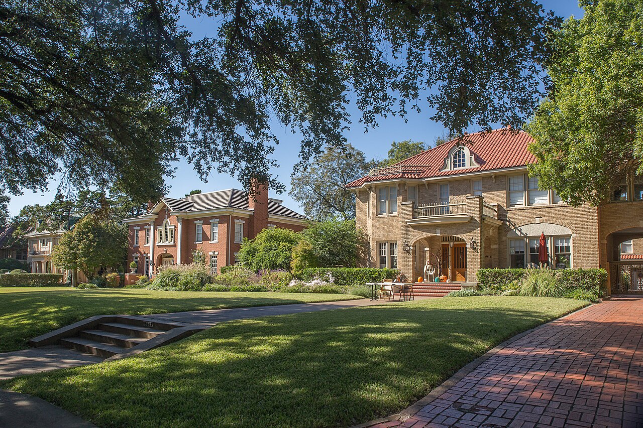
The Greenland Hills addition between Central Expressway and Greenville Avenue, 858 single-family houses, four in five of them built in the 1920s and 1930s, where since 2002 a new house must be built in the High Tudor style and a High Tudor house may come down only if repairs would cost more than 80% of its appraised value.
Frank and Fletcher McNeny platted 98 acres of the Bennett farm as Greenland Hills in 1923, between the railroad that later became the route of Central Expressway and the Interurban line on Matilda Street, and builders such as C.L. Sowell filled it with brick and stone veneer houses; the City's 2002 plan for the district counted 65% of its structures in the Tudor style. The Council made the area the M Streets Conservation District on 13 November 2002, and the 2020 census counted 2,077 people on its 40 blocks, with owners in 79% of the occupied homes. Zillow put the typical single-family home in ZIP code 75206, which holds the whole district and about twelve times its ground, at $756,781 in August 2026.
Four in five houses from the 1920s and 1930s, and an ordinance that writes the next one's roof
The City of Dallas's M Streets Conservation District, Conservation District No. 9, as Ordinance 25116 describes it: the center line of the alley between McCommas Boulevard and Longview Street on the north, the center line of Greenville Avenue on the east, the center line of the alley between Vanderbilt Avenue and Goodwin Avenue on the south, and the center line of US 75, Central Expressway, on the west, less a few excluded lots, about 176 acres by the ordinance and about 214 as the City's zoning layer draws it. Its houses face McCommas Boulevard, Morningside, Mercedes, Merrimac, Monticello, Ridgedale and Vanderbilt avenues and Homer Street. The Greenland Hills Neighborhood Association's area on the City's map covers all but about 36 acres of it. Across Greenville Avenue lies the M Streets East Conservation District, and across the southern alley the Vickery Place Conservation District; Mockingbird Lane is about 670 meters north, beyond Glencoe Park. All of it is in ZIP code 75206.
In 1923 Frank and Fletcher McNeny platted 98 acres of the Bennett farm as Greenland Hills, between the railroad that later became the route of Central Expressway and the Interurban line on Matilda Street, and builders such as C.L. Sowell filled it with brick, stone and stucco veneer houses, Tudor above all. The appraisal district dates 528 of today's 858 houses to the 1920s and 171 to the 1930s. Wikipedia says the name M Streets comes from McCommas and Monticello and the many smaller streets that start with M; Ridgedale, Vanderbilt and Homer do not, and no source this guide found says how the streets got their M names. This guide covers the City's M Streets Conservation District, from Central Expressway to Greenville Avenue and from the alley north of McCommas Boulevard to the alley south of Vanderbilt Avenue: about 176 acres by the ordinance and 214 as the zoning layer draws it, with 2,077 residents at the 2020 census against 1,903 in 2010. Wikipedia's figure of about 6,000 is not the census count for these blocks.
A new house here has to be High Tudor. More than 75% of owners petitioned for the district, and the City's plan named what they wanted stopped: demolitions, oversized new construction and excessively large rear additions. The Council passed Ordinance 25116 on 13 November 2002, and the regulations it now carries, rewritten in 2013, are specific. Only single-family houses, and no more units on a lot. A new house must have a side-gabled roof pitched between 45 and 70 degrees, no hipped roof, brick or stone walls, a dominant front gable and at least four of eight listed features, from an arched doorway to a massive front chimney. Nothing may rise above the line of sight from a six-foot person standing in the middle of the street to the ridge of the side gable, or above 30 feet, and the City's plan applies that limit to additions as well as new houses; side gables must keep at least 30% of their back slope. Lots may cover 45%, garages sit in the rear 30% of the lot, and each house gets one straight driveway on its east side. Standing-seam metal, rolled and tar-and-gravel roofing are barred on the front, the wrap-around and any garage the street can see.
An old High Tudor house is hard to take down. Demolition is allowed only if bringing the house up to code with similar materials would cost more than 80% of its value on the appraisal roll; a non-Tudor house may be remodeled in its own style or in High Tudor. The roll shows how much has been rebuilt anyway: 97 of the 858 houses date from 2000 or later, with a median of 3,394 square feet of living space against 1,921 for those built before 1950. The lots are even, the middle half between 7,136 and 7,650 square feet, and the ordinance caps a lot's width at 60 feet. Two more conservation districts adjoin it: M Streets East, across Greenville Avenue since 2004, and Vickery Place, to the south since 2006.
Owners hold four in five of the occupied homes. In 2020 owners lived in 678 of the 860 and 21% of residents were under 18. No price index follows the district's line. Zillow's single-family figure for ZIP code 75206, which holds the whole district and about twelve times its ground, was $756,781 in August 2026, up 3.6% on the year; the citywide MLS median single-family sale was $469,900, down 6.0%. The census survey's owners, in the block group that holds more than half the district's homes, put the median at $915,600, give or take $65,692, and the two sources do not agree. On the 2025 rates a homestead at Zillow's figure owes the five taxing units about $12,842 a year and the same house without the exemption about $16,851; the arithmetic is on the Dallas page. No public improvement district reaches the district.
The flood map touches a third of the houses. The City's floodplain layer puts about 15% of the district in zones it calls 1% stormwater hazard areas, touching 289 houses, the most on Monticello, Ridgedale and Merrimac, and 11% in a Mill Creek zone the layer does not define; it shows no AE zone. SMU/Mockingbird Station is about 820 meters north of the district's edge, Route 205 runs on the Central Expressway frontage roads and Route 3 on Matilda Street, a block east of Greenville. For the St. Patrick's Day Block Party on 14 March 2026, the City limited the M streets to residents' traffic from 7 a.m. to 8:15 p.m.
- Check whether the house is listed as High Tudor in the district's conceptual plan: that decides whether it can come down
- Have an architect or engineer work out the line-of-sight height before you price a second story
- Pull the City's floodplain map for the lot: 289 of the district's 858 houses touch a stormwater hazard zone
- Confirm Mockingbird Elementary for the exact address with Dallas ISD's school finder
- Work the tax out on your own price, because the seller's capped value ends with the sale
How the M Streets got here
- 1923Frank and Fletcher McNeny subdivide and plat 98 acres of the Bennett farm as Greenland Hills, between the Houston and Texas Central tracks and the Interurban line on Matilda Street.
- 1920sBuilders including C.L. Sowell and the Messerole Brothers put up brick, stone and stucco veneer houses in historical revival styles, Tudor above all; the appraisal district dates 528 of today's 858 houses to the decade. Mockingbird Lane becomes the northern boundary of the city.
- 1930sThe subdivision keeps selling through the Depression, and the appraisal district dates 171 more houses to the decade; the neighborhood historian's account in the City's plan calls Greenland Hills the farthest north development in Dallas at the time.
- 1939Stonewall Jackson Elementary School opens on 13 September on Mockingbird Lane, east across Greenville Avenue; it is the district's zoned elementary, as Mockingbird Elementary, today.
- 1944Glencoe Park, 14.1 acres on Martel Avenue just north of the district, is established.
- 1997DART's Mockingbird station opens on 10 January, about 820 meters from the district's northern edge.
- 2001More than 75% of property owners sign a petition to explore a conservation district, the application goes in that fall, and in December the City Plan Commission authorizes a hearing.
- 2002Five community meetings from 30 January to 21 August draw between 56 and 125 people each; the draft is set for the Plan Commission on 10 October, and on 13 November the Council passes Ordinance 25116, creating Conservation District No. 9 on about 176 acres.
- 2004On 14 January the Council creates the M Streets East Conservation District across Greenville Avenue.
- 2006On 28 June the Council creates the Vickery Place Conservation District, which adjoins the M Streets district to the south.
- 2010The census counts 1,903 residents and 974 homes on the blocks inside today's district.
- 2013On 27 March Ordinance 28946 creates Subarea 1, about a third of an acre at Greenville and Vanderbilt avenues, with its own commercial standards.
- 2018On 1 July Stonewall Jackson Elementary becomes Mockingbird Elementary.
- 2020The census counts 2,077 residents and 948 homes inside the district; owners live in 678 of the 860 occupied homes.
- 2026On 14 March, for the St. Patrick's Day Block Party on Greenville Avenue, the City limits Morningside, Mercedes, Merrimac, Monticello, Ridgedale and Vanderbilt to residents' traffic from 7 a.m. to 8:15 p.m.

Glencoe Park above McCommas, the Katy Trail across the freeway
The City's parks layer puts no park inside the district. Glencoe Park, 14.1 acres on Martel Avenue about 160 meters north of it, dates from 1944 and has softball and rugby fields, a tennis court, a playground and trails. The Katy Trail passes about 140 meters west, beyond Central Expressway. Tietze Park, east through Lower Greenville, has the nearest City pool.

What the map does not show: the freeway. The trail is 140 meters away on the layer, but the connection this guide can source is at Mockingbird Station. The photographs above are of Klyde Warren Park, White Rock Lake and Fair Park, elsewhere in the city.
Elsewhere in Dallas, not M Streets



27 places, with real drive times
Road-adjusted distance and drive time from the centre of the community to each destination, nearest first. Filter by category.
Showing 1–12 of 27 places, nearest first.
Method: distances and drive times are computed from the population-weighted center of the census blocks inside the district, on Merrimac Avenue, using straight-line distance multiplied by a road factor and a tiered speed model: honest ranges, not routed times.
Every gym within reach
There is no City recreation center or pool inside the district. Tietze Pool is about 2 km east; the City's Exall Recreation Center on Adair Street, with a fitness center, and Ridgewood/Belcher on Fisher Road, with a gymnasium, are about 5 km away in different directions and keep the same hours.
- Tietze Pool, 6115 Llano Avenue: about 2.0 km; the City publishes no 2026 hours on its page
- Exall Recreation Center, 1355 Adair Street: about 5.0 km, open to 8 p.m. Monday to Thursday
- Ridgewood/Belcher Recreation Center, 6818 Fisher Road: about 5.1 km, on the same hours
| Facility | What it is | Drive |
|---|---|---|
| Tietze Pool open | The City's nearest community pool, at 6115 Llano Avenue in Tietze Park, east through Lower Greenville. The park department's page lists no 2026 hours or fees and points to Dallas Aquatics for the season. | 5–7 min |
| Exall Recreation Center open | A City recreation center at 1355 Adair Street, just off Central Expressway at Live Oak Street, south of the district: a fitness center with showers, an outdoor basketball court, a baseball field and trails. Open 9 a.m. to 8 p.m. Monday to Thursday, 2 to 7 p.m. Friday and 9 a.m. to 2 p.m. Saturday; closed Sunday. | 8–11 min |
| Ridgewood/Belcher Recreation Center open | The City's recreation center at 6818 Fisher Road north of Mockingbird Lane: a gymnasium, a fitness center, a sprayground and a tennis court, on the same weekly hours as Exall. | 8–11 min |
| Katy Trail open | The free option: the trail, reached from Mockingbird Station, or the trails and courts in Glencoe Park, just north of the district. | 4–6 min |
The free option is Glencoe Park's trails and courts, just north of McCommas, or the Katy Trail from Mockingbird Station.
Mockingbird, Long and Woodrow Wilson for every block
Schools are the Dallas Independent School District's, and on its 2026-27 boundaries all 39 populated blocks in the district, 2,077 residents in 2020, go to Mockingbird Elementary, across Greenville Avenue on Mockingbird Lane, then to J.L. Long Middle and Woodrow Wilson High, south of Gaston Avenue. The elementary opened as Stonewall Jackson in 1939 and took its present name in 2018; the Texas Education Agency rated it B for 2026 after an A for 2025.
| School | Board | Note |
|---|---|---|
| Mockingbird Elementary School | Dallas Independent School District | 5828 East Mockingbird Lane, east across Greenville Avenue. On the district's 2026-27 attendance boundaries it is the elementary for all 39 populated census blocks in the conservation district, 2,077 residents in 2020; one empty block at the western edge falls in Milam's zone. It opened as Stonewall Jackson Elementary on 13 September 1939, took its present name on 1 July 2018, and Wikipedia counts Greenland Hills among the areas it serves. Rated B, 89, for 2026 and A, 93, for 2025. |
| J.L. Long Middle School | Dallas Independent School District | 6116 Reiger Avenue, south of Gaston Avenue: the zoned middle school for every populated block. Rated C, 77, for 2026 and B, 82, for 2025. |
| Woodrow Wilson High School | Dallas Independent School District | 100 South Glasgow Drive: the zoned high school for every populated block. Rated B, 87, for 2026 and B, 83, for 2025. |
Check the exact address with the district's school finder before you commit. Zones are drawn from capacities and enrollment projections and can move.
Month by month, what living here looks like
Not a highlights reel: the actual annual rhythm, including the dates residents have to remember.
- The appraisal district values every house as it stands on 1 January, and last year's tax bill is delinquent if it is unpaid after 31 January
- The first community meeting on the conservation district drew 110 people on 30 January 2002
- Highs near 14 °C and lows near 3 °C at Love Field, with about nine nights at or below freezing on the 1991 to 2020 normal
- The Greenland Hills association's FAQ points residents to the City's bulk trash collection in the second full week of each month, and to the City's tree programs
- Highs near 17 °C and 71 mm of rain, with four or five nights at or below freezing
- For the St. Patrick's Day Block Party on 14 March 2026, Greenville Avenue was closed from McCommas Boulevard to Belmont Avenue and Morningside, Mercedes, Merrimac, Monticello, Ridgedale and Vanderbilt were limited to residents' traffic from 7 a.m. to 8:15 p.m.
- The Council created Subarea 1 at Greenville and Vanderbilt on 27 March 2013; highs near 21 °C and 88 mm of rain
- The Greenland Hills Neighborhood Association holds its annual member meeting in April at Unity on Greenville, 3425 Greenville Avenue; dues are $30 a year and the crime watch patrol $225
- The appraisal district's protest season opens around 15 April; a buyer's first value is the market's, because the seller's homestead cap ends with the sale
- The 2002 meeting on site and architectural standards and demolitions was held on 24 April and drew 86 people
- 15 May is the deadline to protest the appraisal district's value, or 30 days after the notice is delivered if that is later
- 116 mm of rain on the normal, the second wettest month; 289 of the district's 858 houses touch a zone the City's floodplain map calls a 1% stormwater hazard area, the most on Monticello, Ridgedale and Merrimac
- Tietze Pool, east through Lower Greenville, is the nearest City pool; its page points to Dallas Aquatics for the season's hours and fees
- Highs near 34 °C, with about 22 days reaching 32 °C (90 °F) on the normal
- The appraisal district's protest hearings wrap up by 20 July, and the chief appraiser then certifies the roll
- Highs near 36 °C and 43 mm of rain, the driest month, with about 28 days reaching 32 °C
- School starts at Mockingbird Elementary, across Greenville Avenue, and at J.L. Long and Woodrow Wilson, south of Gaston Avenue
- The last of the five 2002 meetings, on 21 August, reviewed every standard for a final endorsement
- Highs near 36 °C, with about 10 days reaching 38 °C (100 °F) at Love Field on the normal
- The association's annual all-neighborhood meeting is in September, at Unity on Greenville
- The five taxing units adopt their 2026 rates; this guide's tax arithmetic stays on the 2025 rates, which add to 2.22671 per $100 before exemptions
- Highs near 32 °C and 79 mm of rain as the storms come back
- Dallas County mails the tax statements in October; they are due on receipt and delinquent after 31 January
- The draft ordinance was set for the City Plan Commission on 10 October 2002; 122 mm of rain at Love Field, the wettest month on the normal
- The Council passed Ordinance 25116, creating the M Streets Conservation District, on 13 November 2002
- Highs near 20 °C and lows near 9 °C
- The City Plan Commission authorized the hearing that led to the district in December 2001
- Appraisal districts value property at market value as of 1 January, so a house finished or torn down before the new year is appraised as it stands then
- Highs near 15 °C, with six or seven nights at or below freezing on the normal
5 more photographs of Dallas and the region
Drawn from the site's shared, freely licensed Dallas photo library, not photographs of M Streets itself. Filter by category.


Showing 1–5 of 5 photographs.
About these photographs. Openly licensed images from the site's shared Dallas library, found on Wikimedia Commons and served from there with full attribution. None of them is presented as a photograph of M Streets.