
Live in Munger Place
Robert Munger's 1905 addition of two-story Prairie houses, a City historic district since 1980, where a new house must have two stories and cover no more than 35% of its lot, and any exterior change needs a certificate of appropriateness.
Robert S. Munger bought 300 acres in 1905 for Munger Place, billed as the first deed-restricted neighborhood in Texas, where a house had to be two full stories, cost at least $2,000 and not face a side street; the City calls what survives the largest intact collection of Prairie-influenced houses in North Texas. During the Depression many owners split their houses into apartments; after the Historic Preservation League helped set up a revolving fund in 1976, 27 houses were bought and resold with restoration covenants by 1979, and the City made the area a historic district on 20 August 1980. The appraisal roll now counts 194 single-family houses, 38 apartment properties and 9 duplexes on its 84.6 acres, and the 2020 census counted 1,248 people on the 24 blocks around them. Zillow put the typical home in ZIP code 75214, which holds 181 of the houses, at $841,168 in August 2026.
A 1905 addition of Prairie houses, brought back from apartments under rules that still favor one family
The City of Dallas's Munger Place Historic District, H/11, which is Planned Development District 97: in the ordinance's words, property southeast of the alley between Gaston Avenue and Junius Street, southwest of Dumas Street and Henderson Avenue, west of Munger Boulevard, northwest of the alley between Columbia Avenue and Reiger Avenue, and northeast of Fitzhugh Avenue and Prairie Avenue, about 84.6 acres. Its houses face Junius, Worth, Victor and Tremont streets and Reiger Avenue. The National Register district listed in 1978 is described as roughly bounded by Henderson, Junius, Prairie and Reiger. On the City's map of historic districts, Junius Heights adjoins it to the northeast, Peak's Suburban Addition to the west across Fitzhugh Avenue, and the Swiss Avenue district lies about 150 meters to the northwest, beyond Gaston Avenue.
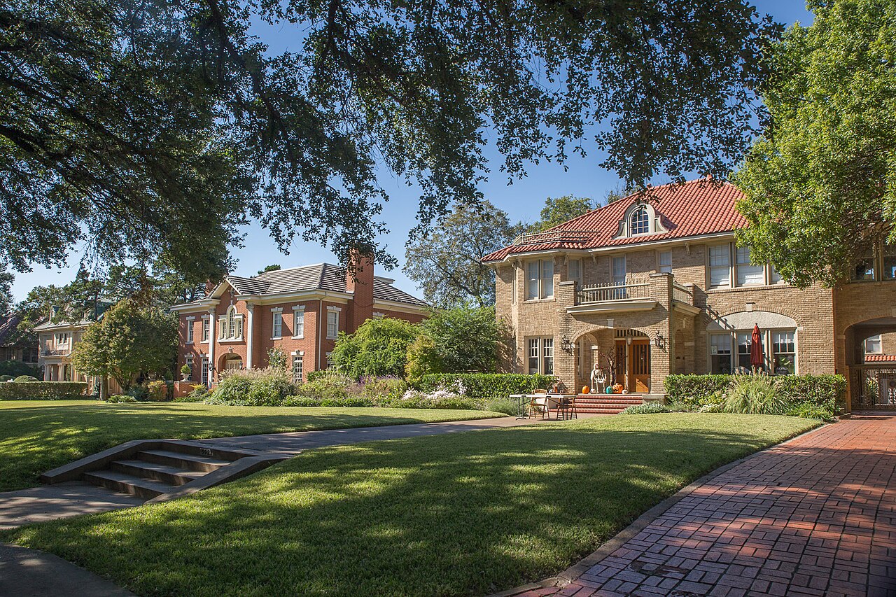
Robert S. Munger, a cotton gin manufacturer, bought 300 acres east of downtown in 1905 and sold Munger Place, billed as the first deed-restricted neighborhood in Texas, with rules on every lot: a house of two full stories, costing at least $2,000, set 25 feet back and never facing a side street. The houses that went up, mostly two-story Prairie four squares with broad porches and low hipped roofs, are what the City calls the largest intact collection of Prairie-influenced structures in North Texas; Preservation Dallas claims the largest collection of Prairie four squares in the United States, and neither says how it counted. This guide covers the Munger Place Historic District as the City draws it: 84.6 acres of Junius, Worth, Victor and Tremont streets and Reiger Avenue between Fitzhugh and Henderson avenues, with the Swiss Avenue district across Gaston Avenue to the northwest.
The houses came back one at a time. In the Depression many owners split their houses into apartments and took in boarders, the post-war housing shortage sped the conversions, and by the 1960s, in Wikipedia's account, houses were coming down. In 1976 the Historic Preservation League helped set up the Munger Place revolving fund; between then and 1979, 27 houses were bought and resold with restoration covenants, and Preservation Dallas puts the private reinvestment at about $5 million. The City zoned the area as PD 97 in April 1978 and laid its historic overlay on 20 August 1980. The City's open data dates the district to 1981 and its own page to 1988, the year of the ordinance that governs it now.
The rules favor the single-family house. In Tract A, most of the district, a duplex or apartment use may not go into a building built for one family, and an existing one loses its right to continue once it stops or the building stands empty for six months; no building may add a unit. A new main building must have two stories, stand no taller than 36 feet and no wider than 42, cover no more than 35% of its lot and keep a 25-foot front yard. Facades are brick, wood siding or stucco; a front porch must be fully covered, 8 to 10 feet deep and never enclosed; and each house needs a roll step lined up with its front door. Staff decide routine repairs and paint in the approved range within 10 days, other work goes to the Landmark Commission, and each day of a violation can cost up to $2,000.
Most homes here are rented. The appraisal roll lists 194 single-family houses on a median lot of 8,376 square feet, and also 38 apartment properties and 9 duplexes. The 2020 census counted 1,248 people on 24 blocks, against 1,257 in 2010; on the 13 populated blocks at least 90% inside the line, owners lived in 137 of 359 occupied homes. No price index follows the district. Zillow's figure for ZIP code 75214, which holds 181 of the houses, was $841,168 in August 2026, up 4.1% on the year; 75246, with the other 13, was $381,857; the citywide MLS median single-family sale was $469,900, down 6.0%. On the 2025 rates a homestead at the 75214 figure owes the five taxing units about $14,429 a year, and about $18,730 without the exemption; the arithmetic is on the Dallas page.
The flood map is the City's own. Its floodplain layer shows no A or AE zone here, but it marks 57% of the district as a "1 PCT stormwater hazard area" and 27% as "Peak's Branch PFP", zones its metadata does not define; 99 of the 194 houses sit in the first at the middle of the lot. The Mill Creek drainage tunnel voters approved in 2012 serves Peaks Branch, but the City's FAQ says it will not appreciably reduce flooding upstream of it, and this guide could not find which side the district is on. Day to day, DART's Route 249 runs on Columbia Avenue every 30 minutes at peak, the Green Line stops at Fair Park about 1.5 km south, and Baylor University Medical Center is about 1.2 km southwest.
- Find the lot's tract, A to D, on the ordinance's map before planning any change
- If a house built for one family holds apartments, confirm the units are still legal before paying for them
- Pull the City's floodplain map for the lot: 99 of the 194 houses sit in its stormwater hazard area
- Check the elementary for the exact address: the 4800 block of Tremont Street goes to Zaragoza, not Lipscomb
- Work the tax out on your own price, because the seller's capped value ends with the sale
How Munger Place got here
- 1905Robert S. Munger, a cotton gin manufacturer, buys 300 acres for Munger Place, with his son Collett as general manager. Billed as the first deed-restricted neighborhood in Texas, it requires houses of two full stories, costing at least $2,000 and not facing a side street.
- 1930sDuring the Depression many owners convert their two-story houses into apartments and take in boarders; after World War II the housing shortage speeds the conversions.
- 1972Citizens found the Historic Preservation League in September, now Preservation Dallas.
- 1976The league helps set up the Munger Place Historic District Revolving Fund. Between 1976 and 1979, 27 houses are bought and resold with restoration covenants, and the area draws about $5 million of private reinvestment.
- 1978On 26 April the City Council passes Ordinance 15820, creating Planned Development District 97, and on 13 September the district is listed on the National Register of Historic Places.
- 1980On 20 August Ordinance 16658 lays a historic overlay, H/11, on the PD. Uses that were illegal that day stay illegal, and lots platted by then remain legal building sites.
- 1988Ordinance 20024, passed on 27 July, combines the PD and the historic rules and divides the district into Tracts A to D, with Tract A for single-family Prairie houses.
- 1995Ordinance 22361 amends the district on 22 March; two weeks earlier, on 8 March, Peak's Suburban Addition across Fitzhugh Avenue becomes a City historic district.
- 2005Munger Place marks its centennial in April.
- 2009Junius Heights, which adjoins Munger Place to the northeast, becomes a City historic district on 9 September.
- 2010The census counts 1,257 residents and 678 homes on the 24 blocks whose internal point falls inside the district.
- 2012On 6 November voters approve Proposition 2, to relieve flooding along Mill Creek, Peaks Branch and State Thomas; the City's answer is a drainage tunnel of about five miles to White Rock Creek.
- 2020The census counts 1,248 residents and 646 homes on the same 24 blocks; owners live in 183 of the 585 occupied homes.
- 2026Dallas ISD's 2026-27 map zones 181 of the 194 houses to Lipscomb Elementary and the 13 on the 4800 block of Tremont Street to Zaragoza Elementary.


Munger Park, the Santa Fe Trail and Fair Park
The only City park inside the district is Munger Park, 0.54 acres with a playground at 5300 Junius Street. The Santa Fe Trail, 4.7 miles on a former rail line from near Deep Ellum to White Rock Lake, passes about 340 meters southeast. Fair Park's 262.8 acres begin about 1.4 km south, and Samuell-Grand Park, 80.9 acres with a pool, a tennis center and a golf course, about 1.4 km east.
What the map does not show: the ordinance reaches the parkway, the strip between each front lot line and the street: only grass, trees from its list, ground cover and flowers, with the trees in a line at even spacing. The photographs above are of White Rock Lake, Klyde Warren Park and the Trinity floodway, elsewhere in the city.
Elsewhere in Dallas, not Munger Place


32 places, with real drive times
Road-adjusted distance and drive time from the centre of the community to each destination, nearest first. Filter by category.
Showing 1–12 of 32 places, nearest first.
Method: distances and drive times are computed from the population-weighted center of the district's 2020 census blocks, on the 5000 block of Victor Street, using straight-line distance multiplied by a road factor and a tiered speed model: honest ranges, not routed times.
Every gym within reach
There is no City recreation center in the district. The nearest, Exall on Adair Street to the west, has a fitness center with showers and an outdoor basketball court; Samuell Grand, to the east, is nearly four times its size, with a gymnasium and tennis courts, and its park has the City's nearest pool. The White Rock YMCA on Gaston Avenue has an outdoor pool and a weight room.
- Exall Recreation Center, 1355 Adair Street: about 2.6 km
- Samuell Grand Recreation Center, 6200 East Grand Avenue: about 2.8 km
- White Rock YMCA, 7112 Gaston Avenue: about 4.0 km, from 5 a.m. on weekdays
| Facility | What it is | Drive |
|---|---|---|
| Exall Recreation Center open | The City's nearest recreation center, at 1355 Adair Street west of the district: 5,300 square feet, built in 1989, with a fitness center with showers, an outdoor basketball court, a baseball field and trails. Open 9 a.m. to 8 p.m. Monday to Thursday, 2 to 7 p.m. Friday and 9 a.m. to 2 p.m. Saturday; closed Sunday. | 6–8 min |
| Samuell Grand Recreation Center open | The City's community center at 6200 East Grand Avenue in Samuell-Grand Park, east of the district: 20,272 square feet, built in 1964, with a gymnasium, a fitness center with showers and tennis courts, on the same hours as Exall. | 6–8 min |
| Samuell Grand Pool open | The City's nearest community pool on its aquatic facilities layer, at 3201 Samuell Boulevard in Samuell-Grand Park. | 6–8 min |
| White Rock YMCA open | The YMCA of Metropolitan Dallas branch at 7112 Gaston Avenue, northeast of the district: an outdoor pool, a weight room, a basketball court and pickleball courts. Open 5 a.m. to 10 p.m. Monday to Thursday, with shorter hours from Friday to Sunday. | 6–10 min |
| Santa Fe Trail open | The free option: the City's 4.7-mile trail on a former railroad line, about 340 meters southeast of the district, running east to White Rock Lake. | 3–4 min |
The free option is the Santa Fe Trail, about 340 meters southeast, which runs on to White Rock Lake.
Lipscomb for most houses, Zaragoza for one block
Schools are the Dallas Independent School District's. On its 2026-27 boundaries, 181 of the district's 194 houses go to Lipscomb Elementary on Worth Street, then to J.L. Long Middle and Woodrow Wilson High, all northeast of the district; the 13 houses on the 4800 block of Tremont Street go to Zaragoza Elementary, Spence Middle and North Dallas High. The Texas Education Agency rated Lipscomb B, 83, for 2026, Long C, 77, and Woodrow Wilson B, 87; Zaragoza B, 80, Spence B, 84, and North Dallas B, 86.
| School | Board | Note |
|---|---|---|
| Lipscomb Elementary School | Dallas Independent School District | 5801 Worth Street, northeast of the district. On the school district's 2026-27 elementary boundaries, 181 of the 194 houses and 23 of the 24 census blocks, with 1,187 of the 1,248 residents of 2020, are in its zone, which feeds J.L. Long and Woodrow Wilson. The Texas Education Agency rated William Lipscomb Elementary B, 83, for 2026 and B, 88, for 2025; 70.4% of its students counted as economically disadvantaged in the 2026 rating. |
| Zaragoza Elementary School | Dallas Independent School District | 4550 Worth Street, southwest of the district. Its zone takes the 13 houses on the 4800 block of Tremont Street, about 6% of the district's area, and feeds Spence Middle School and North Dallas High School. The Texas Education Agency rated Ignacio Zaragoza Elementary B, 80, for 2026, with 95.8% of its students economically disadvantaged; it rated Spence, which it lists as the Alex W Spence Talented/Gifted Academy, B, 84, and North Dallas High B, 86. |
| J.L. Long Middle School and Woodrow Wilson High School | Dallas Independent School District | 6116 Reiger Avenue and 100 South Glasgow Drive, northeast of the district: the zoned middle and high schools for every Lipscomb house. The Texas Education Agency rated Long C, 77, and Woodrow Wilson B, 87, for 2026, with 45.9% and 52.8% of their students economically disadvantaged. |
Check the exact address with the district's school finder before you commit. The line between the two zones runs through the historic district, and the zone map used here was last edited in July 2026.
Month by month, what living here looks like
Not a highlights reel: the actual annual rhythm, including the dates residents have to remember.
- The appraisal district values every house as it stands on 1 January, and last year's tax bill is delinquent if it is unpaid after 31 January
- The Landmark Commission typically sits on the first Monday of every month; an application for its full review is typically due by noon on the fourth Monday of the month before
- Highs near 14 °C and lows near 3 °C at Love Field, with about nine nights at or below freezing on the 1991 to 2020 normal
- Repainting the same color is routine maintenance; a new color must fall in the ordinance's acceptable color range, with one dominant color and no more than three trim colors, and brick that has never been painted may be painted only in the cases the ordinance allows
- Highs near 17 °C and 71 mm of rain
- Cacti, vegetable gardens, rock gardens and lawn ornaments are not allowed in the front yard, and parkway trees must come from the ordinance's list, planted in a line at even spacing
- Highs near 21 °C and 88 mm of rain
- Munger Place marked its centennial in April 2005
- The appraisal district's protest season opens around 15 April; a buyer's first value is the market's, because the seller's 10% homestead cap ends with the sale
- Highs near 25 °C and lows near 14 °C
- The Swiss Avenue Historic District's 51st Mother's Day Home Tour ran on 9 and 10 May 2026, about 150 meters northwest across Gaston Avenue
- 15 May is the deadline to protest the appraisal district's value, or 30 days after the notice arrives if that is later
- 116 mm of rain on the normal, the second wettest month, on a district the City maps as more than half stormwater hazard area
- The City's nearest pool is in Samuell-Grand Park, east of the district, and the White Rock YMCA on Gaston Avenue has an outdoor pool
- Highs near 34 °C, with about 22 days reaching 32 °C (90 °F) on the normal
- The Council passed Ordinance 20024, today's district rules, on 27 July 1988
- Highs near 36 °C and 43 mm of rain, the driest month, with about eight days reaching 38 °C (100 °F)
- The historic overlay dates from 20 August 1980, and the ordinance still measures legal uses and building sites from that day
- School starts: Lipscomb, J.L. Long and Woodrow Wilson for most houses, and Zaragoza, Spence and North Dallas for the 4800 block of Tremont Street
- Highs near 36 °C, with about 10 days reaching 38 °C (100 °F) at Love Field on the normal
- The district joined the National Register of Historic Places on 13 September 1978
- The State Fair of Texas opens at Fair Park, about 1.4 km south, on 25 September 2026
- The five taxing units adopt their 2026 rates; this guide's arithmetic stays on the 2025 rates, which add to 2.22671 per $100 before exemptions
- Dallas County mails the tax statements in October; they are due on receipt and delinquent after 31 January
- The State Fair runs to 18 October 2026
- 122 mm of rain at Love Field, the wettest month on the normal
- Every house in Tract A needs a front porch or entry treatment; a front porch must be completely covered and 8 to 10 feet deep, or near its neighbor's depth, and may not be enclosed with glass, bars or screening
- Highs near 20 °C and 74 mm of rain, with the first freezing night or two
- Incandescent fixtures 10 inches across or smaller, along the eaves or in a tree, count as a minor exterior alteration under PD 97, and a temporary item in the yard may stand for up to two periods of five days a year
- Highs near 15 °C, with six or seven nights at or below freezing on the normal
4 more photographs of Dallas and the region
Drawn from the site's shared, freely licensed Dallas photo library, not photographs of Munger Place itself. Filter by category.


Showing 1–4 of 4 photographs.
About these photographs. Openly licensed images from the site's shared Dallas library, found on Wikimedia Commons and served from there with full attribution. None of them is presented as a photograph of Munger Place.